
Press Release, August 20, 2026
INLECOM Develops AI-Powered Tool for Road Accident Risk Prediction and Mapping within EVOROADS
Athens, Greece, August 2026 – INLECOM Innovation’s AI-powered road accident risk prediction and mapping tool, developed within the EU-funded EVOROADS project, has been featured on the European Road Safety Charter platform. The feature presents how the tool transforms historical accident records into actionable road-safety intelligence, enabling public authorities and road operators to identify priority areas and adopt a more proactive approach to road-safety planning. Rather than examining only where accidents have already occurred, the tool assesses every road segment according to two complementary dimensions:
- its current accident risk level; and
- its risk trajectory, indicating whether accident risk is increasing, remaining stable or decreasing over time.
Combining these dimensions allows authorities to identify not only established accident hotspots but also road segments where risk is rising. This can support earlier, better-targeted interventions and help decision-makers allocate limited road-safety budgets where they can have the greatest impact.
Validated across the Piedmont road network
The tool was developed during 2024–2025 and is being further enhanced through 2026. It has been validated at full regional scale in Piedmont, Italy, in collaboration with CSI Piemonte, the regional ICT in-house company.
The validation involved the processing of 3,516,774 accident-related records covering the period from 2016 to 2022. The dataset included 68 variables, such as accident locations, injuries, fatalities and traffic-flow characteristics. Using this information, the tool produced risk and trend classifications for 511,165 road segments, corresponding to 99.7% of all segments with at least one recorded accident.
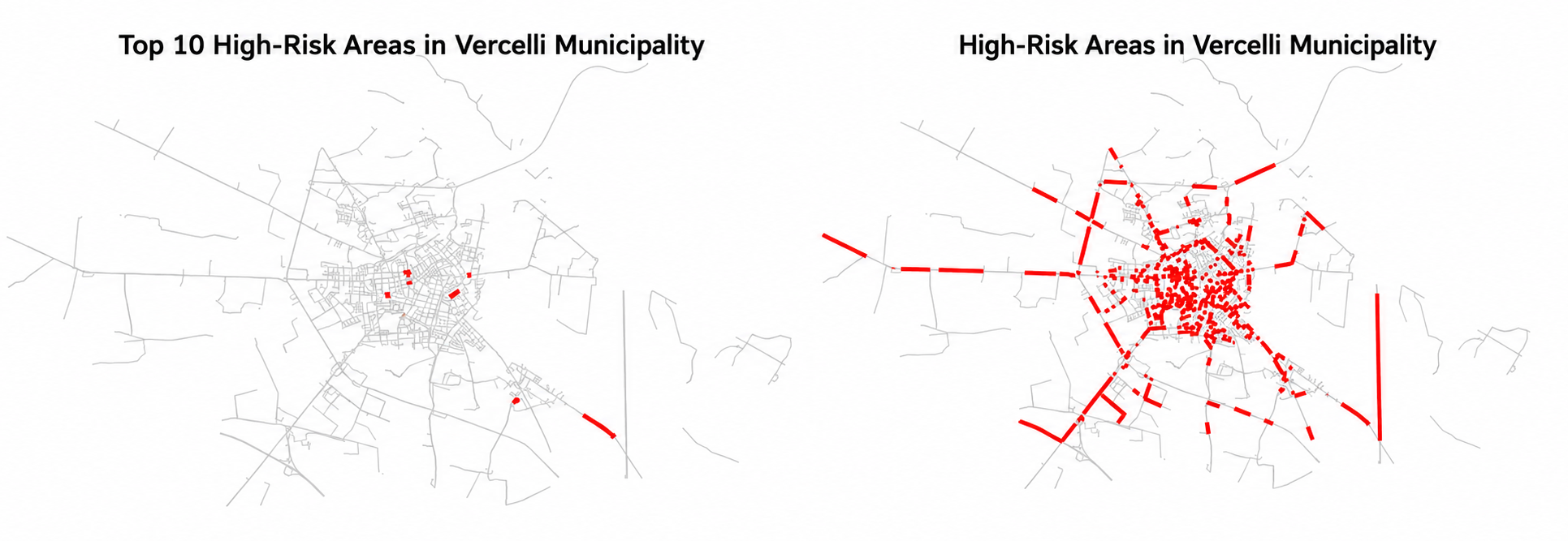
The resulting interactive maps can support practical applications such as:
- identifying the highest-risk road segments within each municipality;
- detecting locations where accident risk is increasing;
- comparing road-safety needs across municipalities;
- prioritising targeted infrastructure interventions; and
- informing the allocation of available road-safety budgets.
Practitioners from CSI Piemonte reviewed the outputs against their knowledge of the regional road network. Their feedback was incorporated throughout the tool’s development, helping ensure that its results respond to the practical needs of road-safety authorities.
A robust and interpretable AI approach
INLECOM developed a dedicated data-integration and preprocessing pipeline to ingest, clean and harmonise multi-year, georeferenced accident data.
A novel spatial aggregation method based on “thickened” road segments was also introduced. This method associates each road segment with its actual spatial neighbours, including junctions, parallel lanes and connecting segments, so that risk calculations reflect real local accident patterns rather than the way individual segments happen to be represented digitally.
Several analytical techniques were systematically tested for the tool’s principal functionalities. The selected approach uses Gaussian Mixture Models to classify road segments into four accident-risk levels, alongside trend estimation and clustering methods that organise their risk evolution into ten more granular classes.
The benchmarking process prioritised statistical robustness, interpretability and resistance to overfitting. This was particularly important because road authorities often hold relatively short annual accident datasets, making some more complex forecasting techniques unreliable.
Designed for replication across Europe
One of the tool’s main advantages is its transferability. It works with georeferenced historical accident data that road authorities already routinely collect and does not require the installation of new sensors or additional physical infrastructure. The methodology can therefore be adapted to other municipalities, regions and road networks, subject to the availability and quality of the relevant local data.
By converting historical records into forward-looking risk intelligence, the tool adds a predictive prioritisation layer to existing road-safety practices. It can help authorities move from responding to past accidents towards identifying where preventive action may be needed most urgently.
INLECOM’s role in EVOROADS
Within EVOROADS, INLECOM Innovation serves as Quality Assurance and Risk Manager. Beyond this role, INLECOM contributes to the development and application of AI-based tools for cyber-physical road infrastructure monitoring and to the integration of solution assessment and risk assessment frameworks.
The accident risk prediction and mapping tool represents a key element of this technical contribution and reflects INLECOM’s expertise in artificial intelligence, predictive analytics and risk assessment.
Through these activities, INLECOM supports EVOROADS’ wider objective of developing data-driven solutions for safer, smarter and more resilient road infrastructure, contributing to the European Union’s Vision Zero ambition of eliminating road fatalities by 2050.
The complete methodology and validation results are documented in the public EVOROADS deliverable D2.1. In a new feature published on the European Road Safety Charter platform, INLECOM’s Konstantinos Loupos presents the AI-powered tool, its development and large-scale validation, and its potential to support more proactive road-safety decision-making across Europe.
Read the complete European Road Safety Charter feature here.
About EVOROADS
EVOROADS (Evolutionary Solutions for Realising a Holistic Safe System Approach for All Road Users) is a Horizon Europe research and innovation project bringing together 20 partners from 10 European countries. Running from May 2024 to April 2027, the project develops innovative models, tools and services for data-driven road-safety assessment, dynamic infrastructure monitoring and proactive risk warning. Its solutions are being validated through Living Labs in Italy, Spain, Latvia and Romania.
EVOROADS has received funding from the European Union’s Horizon Europe research and innovation programme under Grant Agreement No. 101147850.
Funded by the European Union. Views and opinions expressed are, however, those of the author(s) only and do not necessarily reflect those of the European Union or the European Climate, Infrastructure and Environment Executive Agency (CINEA). Neither the European Union nor the granting authority can be held responsible for them.